 |
|
 |
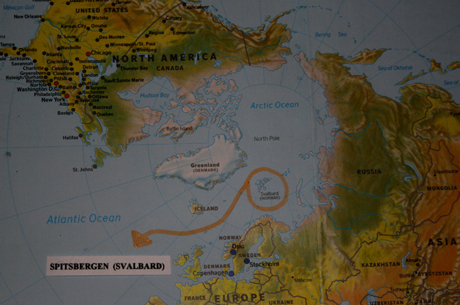
The location of Spitsbergen (svalbard) on the worldmap.
See the map below: The pink stip in the orange circle is the location of my basecamp.
Left under in the orange circle is the Norwegian settlement Longyearbyen.

The islands of Svalbard, Spitsbergen is the main island.
Isfjorden is the big fjord just above Longyearbyen.
The small and very long Weidefjorden can be seen above the orange circle.
The 2 highest mountains of Spitsbergen, Newtontoppen and Perriertoppen, can
be seen at the top of the orange circle.
Maps of the 2010 trips.
It is possible to see a map where the Winter- & Summertrips take place on Spitsbergen.
Every trip has its own map. The route is marked on the map.
Click on the name of the trip to see the map:
Maps of the Winter Trips:
 Moonlight Ski Tour.
Newtontoppen Ski Tour.
Ski Tour from West- to East-Spitsbergen.
Ski Tour Adventdalen.
Maps of the Summer Trips:
Early Summer Ski Tour.
2 Walking Tours over Glaciers.
2 White Water Kayak & Riverboard Tours.
Walking Tour from West- to East-Spitsbergen
and a Luxury 4-5 days Boat Trip.
More maps will be placed at the end of 2009.
Last update on June 11th 2009

The location of Spitsbergen (svalbard) on the worldmap.
The islands of Svalbard, Spitsbergen is the main island.
Moonlight Ski Tour.
Newtontoppen Ski Tour.
Ski Tour from West- to East-Spitsbergen.
Ski Tour Adventdalen.
Early Summer Ski Tour.
2 Walking Tours over Glaciers.
2 White Water Kayak & Riverboard Tours.
Walking Tour from West- to East-Spitsbergen
and a Luxury 4-5 days Boat Trip.
Last update on June 11th 2009